DF Novices - Known Wilderness as of Session 14
Here is a partial hexmap, showing what the party knows of the wilderness so far. My version is a lot more detailed of course; this is the player-facing version.
The crossed swords icon shows the approximate location of their recent fight with some human warriors. The red skull and crossbones is the Bad Magic icon, and signifies the approximate location of the necrotic tree the party encountered and retreated from. The shape of the wilderness is not a neat rectangular shape, and so the Kingdom of Grallmarg can be seen in the bottom-right corner. Abdurna is the city from which the party started their journey. Somewhere on the western side of the wilderness is the Kingdom of Alcyondy.
The crossed swords icon shows the approximate location of their recent fight with some human warriors. The red skull and crossbones is the Bad Magic icon, and signifies the approximate location of the necrotic tree the party encountered and retreated from. The shape of the wilderness is not a neat rectangular shape, and so the Kingdom of Grallmarg can be seen in the bottom-right corner. Abdurna is the city from which the party started their journey. Somewhere on the western side of the wilderness is the Kingdom of Alcyondy.

The hexes indicate a scale of ~6 miles across from side to side (~7 miles across from the vertices), and each marks an area of some 30+ square miles. The map itself was made using Hexographer (I have version 1.x which I bought some years ago, rather than the newer 2.0 Worldographer version). Hexographer has a function to import in an image file, in order to produce a hexmap by "tracing" an existing setting map; I used this to get a reasonable approximation of the major mountains and rivers, and the national borders. For the text on the map, I used Hultog, a free TrueType font created by S. John Ross.
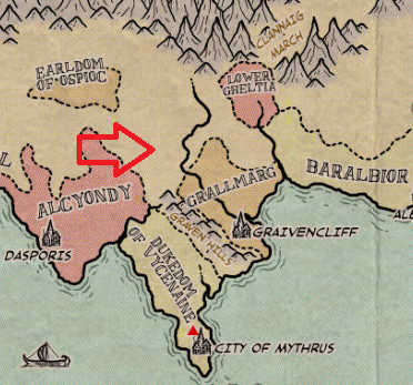
Below is a snip from the original map of the World of Jordoba setting. I have added the giant red arrow to show the relative position of the town of Bridgegate and the surrounding wilderness.
 |
Comments
Post a Comment